
It was already 9:30 when I crossed the Arizona state line and the pavement immediately ran out. I know, I know - that's a decent Harley start time, but a KTM rider should know better! In my defense, I had left my friends' house an hour before. Since then, I'd ridden 30 miles to this same junction, then three more in the wrong direction to fill up with gas at the closest station - and I really filled it up good! After topping off the two main tanks, I put 1.5 gallons in the Kolpin jug on the back, then set my little 1.5 liter Sigg bottle on the pavement and dispensed half a gallon from the pump. Unfortunately, half a gallon is about 1.9 liters.

Fortunately, my feet were not in the way, and the spilled fuel evaporated quickly in the bright morning sun. With my OOPS for the day already behind me, things could surely only get better! I knew I had about 75 miles of gravel to traverse, before arriving at the trail head; and if these first few miles of well-graded and hard-packed rock were any indication, this part was going to be fun!

Besides the new windscreen, I was also sporting new shades on this trip. By far the most money I've ever spent on sunglasses, these polarized, UV-blocking, anti-glare precision ground lenses are the best there is - according to my eye doctor. And when I first put them on, I could immediately tell the difference! Objects that would normally be hidden in the glare on a sunny day, or faded into the background on a cloudy day, stand out in heightened contrast. And the increased peripheral vision clarity reduces eye strain in a way that can really be felt by the end of a long day in the saddle. Besides not being able to see clearly past the tips of my fingers without corrective lens, I've been having other eye problems lately. And when I told my new doc how much riding I do, he said I should try a pair of Maui Jims.
OK, that's the end of the commercial. Where do I pick up my check again, Jim?

Alright, continuing backwards in my story, before the gas station, I was at McDonald's. But it was breakfast, so that makes it OK - quit their burgers decades ago. And my friend was buying, so that makes it even better! Ed meets a bunch of friends there every weekday morning, and when he offered to take me, I couldn't resist. Knowing it was going to be a physically demanding day, I figured fueling up the body as well as the bike, for a change, would probably be a wise use of time. As a bonus, their cheerful greetings and insider stories made me feel like a local in a town where I'd only spent one night. I was a little surprised, however, that with all the combined years of desert life experience at the table, no one had even heard of Kelley Point - only a hundred or so miles to the south. They wished me well though, and looked forward to the report of my safe return.

After leaving the restaurant, we'd made one more stop, at the auto parts store, to get an anti-ethanol additive I'd run out of earlier in my trip. Not only does it counteract the nasty gunk that corn based fuel leaves in your engine, but it increases gas mileage back to what it would have been, if you were running on 100% petrol. And on this day, I was going to need all the mileage I could get to make it back to the pavement!

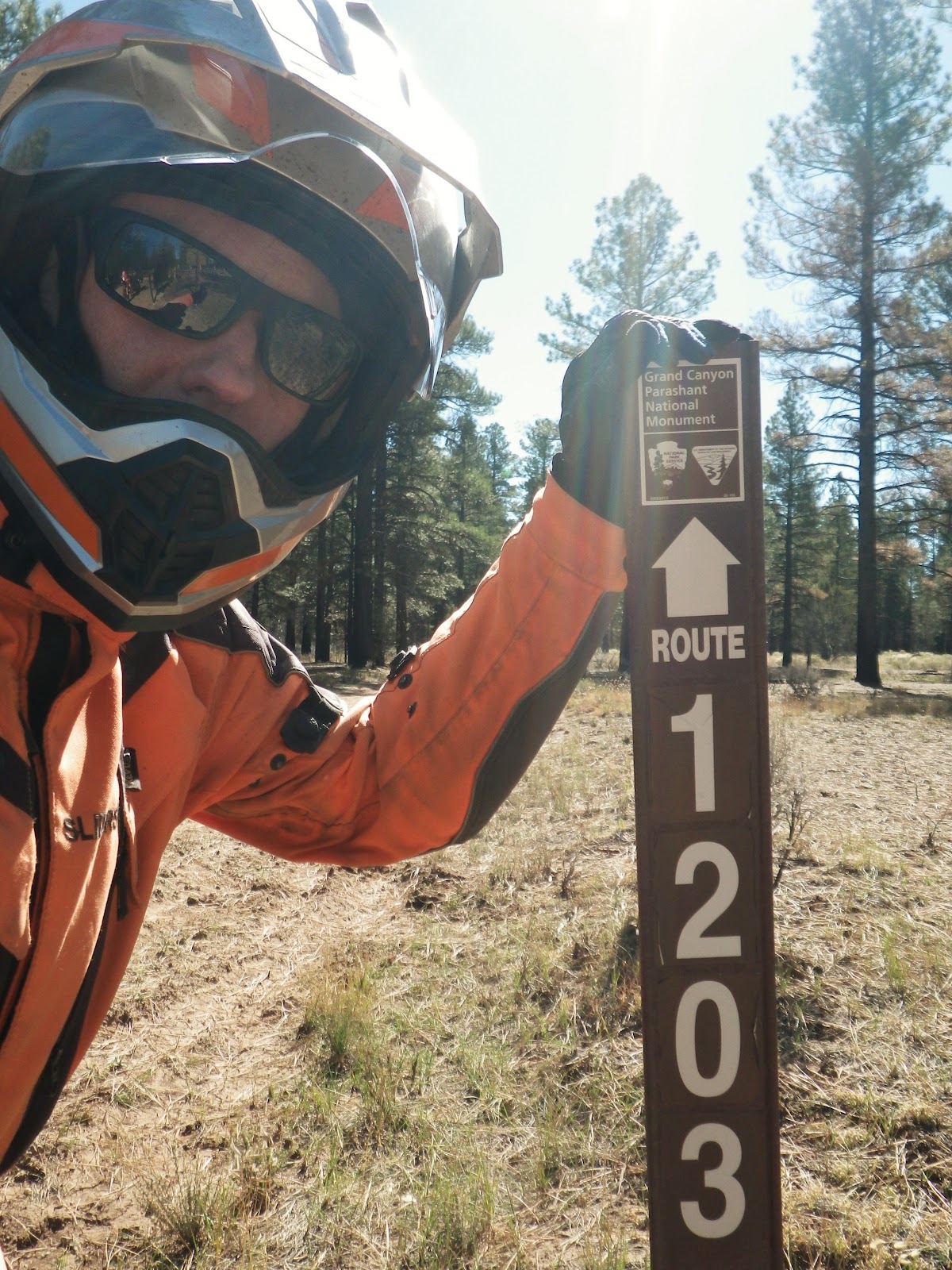
Returning to the present, after dozens of beautiful, solitary, unpaved road miles, I came to a junction with a sign, bearing the names of places I'd been 15 years before. My first KLR, a 1997 model, had brought me safely to and from Mount Trumbull and Toroweap, to the east (left fork), when we lived in Kanab, UT. Now it was finally time to explore this western end of the "Arizona Strip." Comprised of all the land in Arizona north of the Grand Canyon, this region is larger than the state of Massachusetts, but has very few paved roads, only two real towns, and is home to only a few thousand people. It's the perfect adventure bike destination!

The junction in the photo above was far from the first I'd encountered since leaving the pavement. Still resisting the global tide of GPS navigation, I consulted the paper maps I'd slid into the top, see-through pocket of my tank bag. On the one I'm holding, printed off the Internet, I'd marked my route with a highlighter. Showing only primary unpaved roads (an oxymoron, perhaps) it was great for a quick look. If I really got lost, however, I had the yellow one behind. It folds out to the size of my dining room table, and shows every tiny track, down to the cattle paths, I believe!
To the right, the sign indicated I'd find Mount Dellenbaugh, which I didn't think was along my route. But there it was on the map, a bit to the south of my road, so all was well. The sign also indicated "Parashant" in that same direction - the first mention of the monument I'd seen on the ground. I'll admit, I felt a little better after that! Sure, a GPS would make things much easier. But if I wanted easy, I could have just gone to Vegas.

The next road sign was even more helpful, as it confirmed that I was indeed on the official route to Kelly Point! I'd read about the seasonal closure on the Internet. Evidently there are some meadows that can really get destroyed when wet, and winter is the rainy season here. Hopefully, all would still be nice and dry today. There was certainly no rain in the forecast, and when I'd called a few days before, monument staff was not aware of any washouts on the trail.
So far, navigation through the "Strip" had actually been much simpler than many places I've ridden. The signs had not yet been stolen, nor even used as target practice!

And there it was! I've entered through the "back door" of many parks and monuments on narrow dirt roads and taken pictures of tiny, beat up signs on the boundary, this was very different. I guess in this case, I was at the front door, as there are no paved roads leading into Grand Canyon - Parashant National Monument. I liked it!

First order of business was to get the extra weight off the luggage rack and into the gas tank. I'd recently passed the '60 miles from the gas station' mark, so all 1.5 gallons should fit - and it did. That means I was averaging about 40 miles per gallon. All's well so far. Just as I snapped the gas cap closed again, an old livestock truck full of sheep and leading a huge plume of dust drove up. Signaling to the driver that all was well, he waved back and continued on his way to town. Evidently, there are still some operating ranches down here. Nice to know I might not be completely alone after all.

At the junction to Mount Dellenbaugh, I believe, the gravel ran out, and I found myself on a native dirt surface. You can see the deep ruts made by trucks who passed through when it was last muddy. But now it was all dry again, and the going was nice and smooth. If it was like this all the way to the point, I'd be there in no time!

Just across this brand new cattle guard, I passed through an open, solid steel gate. This must be where they close the trail each winter. The pine forest was a welcome change of scenery after all the sage brush, but I had a feeling it wouldn't last.

The Parashant is a joint management effort between the Park Service and the BLM. This sign indicates I'm getting closer to the rim! After the sheep truck, three monument vehicles had passed me heading out. At first, I was pleased there was an official presence in such a remote place. Then I thought, "Those are probably the last of the staff, going home to St. George for the weekend!"
From the gate, the "Jeep" trail portion of my route to Kelly Point was marked with these thin brown posts. It was supposed to be 26 miles to the Grand Canyon overlook from here. I figured at worst, I could average 10 miles per hour on this part. That would mean about two and a half hours out. But the way it looked so far, I might make it in half that time - and it was barely noon. Morale was running high!

And then I spotted this flyer, stapled to another post. Floyd Roberts had been missing for quite a while - last seen June 17. It was now October.
I had lots of water, fuel, tools, an emergency shelter, an extensive first aid kit, and friends who knew where I was going and when I planned to be back. None of that could guarantee a safe return, I knew, but I felt I was as prepared as anyone could be.
Well, there was one more thing I could have done. Just before leaving home, I'd come the closest I have yet to purchasing a satellite locator and communicator. I knew there would be no cell service in the Parashant, but that was really nothing new. Most of the roads I've been riding in northern Canada lately are out of phone range as well. The difference is that those roads, while rough and remote, are the only routes between the towns. As such, it's never terribly long before another vehicle happens by. In parts of the desert southwest, off the proverbial 'beaten path,' however, it might be days before anyone else has a need or desire to pass your way. Parks and monuments are usually fairly well visited, but the Parashant is not your typical family road trip destination. Just how far off the 'beaten path' was Kelly Point? I didn't know.
I put off the decision. Was it the expense, the bother of keeping one more electronic gizmo charged and ready? Or was it deeper than that? Did I fear that having a device that promises to keep me one press of a button from rescue and civilization would be giving up too large a piece of what makes my trips so appealing and satisfying? Would I be giving in to modern society's relentless push to take all the risk out of life - and with it, all the reward?
As with all decisions, if you put them off long enough, they are made for you. Or in this case, it might be closer to the truth to say that failing to make a decision in time, I was, in fact, deciding to keep the status quo. Either way, departure day arrived, and I was not packing a satellite device.
I said a prayer for Floyd, and his family - and for myself - got back on the bike, and continued south, deeper into the Parashant.
No comments:
Post a Comment