Saturday, July 9, 2022

Wyoming Or Bust! Return Leg


From the highway at Four Corners, I back-tracked a few miles to the turn off for Beaver Creek and Mallo Camp.  I didn't see anyone around that day, but from the looks of it (and some post-trip research) Mallo Camp is a facility that can be rented to accommodate hundreds of people for retreats, reunions, etc.  Nice location, but far from any other services.  If you didn't bring it with you, you won't find it there!


After Mallo, the road narrowed considerably, and I thought I might have taken a wrong turn.  The flora had certainly taken a turn, as the ubiquitous ponderosa pine of the Black Hills had been exchanged for a spruce/and/or fir forest that reminded me more of the higher elevations of the Rockies.  Beautiful!


Near the South Dakota border (again unmarked) was a small lake, with trees that appeared to be crawling in for a swim.


Opting not to join them, I continued up the canyon, as the road widened out again.  

Oh yes, that shadow I pointed out at the end of my last blog post - as I rode out from under the driveway of the motel, I crossed the path of a rather large but friendly dog.  I had not noticed him before.  He was likely approaching to see if I had a snack to share.  Give yourself a point if you guessed correctly!


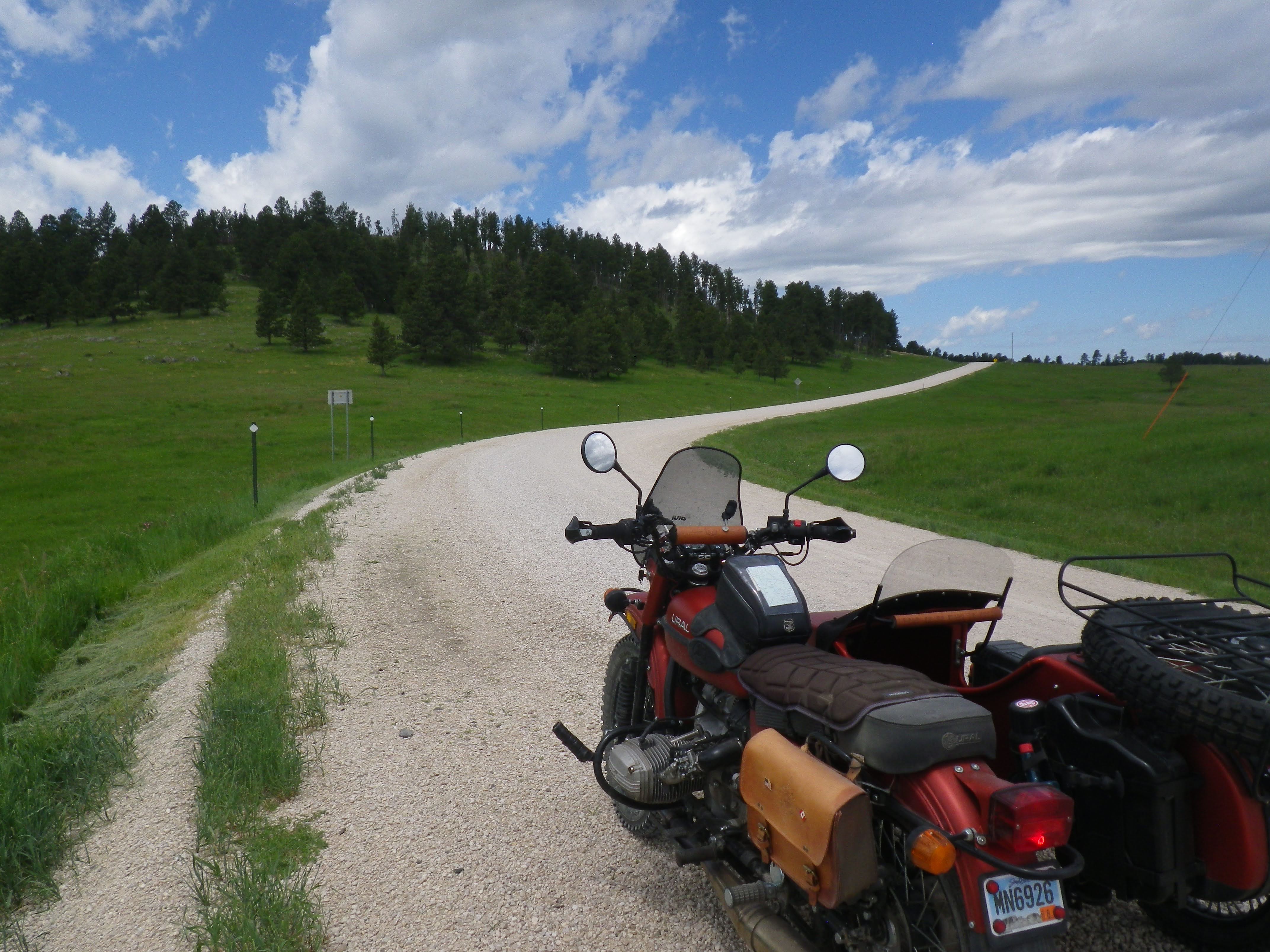
This is a good time to point out some new stickers on the rig - actually the first I've put on the Ural in the 2 1/2 years we've been together.  Guess I decided it was time to truly make it mine.  Really, it's not that great a shot of the decals, so I'll describe them for you.  One you can barely see because of the reflection of the sun.  It's on the tip of the front fender and says "Hemisphere OFFROAD" with URAL in the background.  It came with the engine skid plate I installed before Dan and I began our Idaho adventures.  I've always thought that spot needed something, and when I recently rediscovered this sticker in my tool box, I knew that was it.

The other is more significant.  It's on the front of the sidecar.  It should look familiar to my long-time readers, as a version of it has appeared on two previous motorcycles.  It's a replica of the 20th annual Dakar Rally race decal for 1999.  Kim and I were at the finish line in Senegal, Africa and watched all the bikes, then cars, then support trucks come jumping in over the dunes.  It was quite the experience!  I had the first iteration printed for my 990 KTM, which I bought when I was 40 years old.  It was my 7th bike, so I gave it the number 407.  My second KTM came five years later, and thus was designated number 458.  And so, two years after that, the Ural became 479 - though for some reason, I had been reluctant to officially christen it until right before this trip.  Maybe I just didn't want to cover up so much of that custom 'satin terra cotta' paint job!


While I alternated between reminiscing about the last decade and ruminating about the next one, the sky had grown more than a little ominous.  The forecast had not called for showers that afternoon, but I have been learning that showers are at least somewhat likely every afternoon in The Hills this time of year.  A little rain wouldn't hurt me (and summer mountain storms the world over are usually brief) but large hail sure can - which is certainly not uncommon in these parts.


I could get up under the trees and be fine, but I hadn't seen much shelter lately for the Ural.  Well, there is still one pretty blue spot up there, and I am kind of heading that way...


As I passed another water feature, I couldn't help but notice the contrast between the storm brewing above and the stillness of the pond below.  God doesn't promise a life without storms.  In fact, he assures us that they will come.  But he does provide a way to remain calm in their midst.  This MS diagnosis is not the first storm I've encountered in my half a century on this earth.  And as much as I may wish it was, it will probably not be the last.  God has seen/is seeing me through the previous ones, so I have no reason to doubt Him now.


To get a better view of the landscape, I had stood up on the pegs for a bit - and caught this different perspective of my chosen method of conveyance.  What can I say?  It's a nice looking rig!  Like good music, the 1930s motorcycle vibe has never really gone out of style.


Yes, if you're noticing the mud splashed on the appropriately named 'mud flaps,' I went through a section of road maintenance a while back where they had sprayed down the gravel - with just water, I hoped.  It was not a storm, though that might still be in the cards.  

In this photo, I also wanted to point out the rocky crag ahead.  As I approached the area of the Black Hills most famous for Mt. Rushmore, granite peaks of this sort became more common.  I could also point out the South Dakota license plate where the Oregon one used to be.  Didn't see that change coming a year ago, but so far I'm really enjoying it!


All of a sudden, the ground dropped off and I found myself perched on the rim of a canyon, with the road switch-backing down to the bottom.  Reminded me of some spots along the Idaho Backcountry Discovery Route.  But here, I was only an hour or so from home!


The road became twistier that it had been in a while, and I enjoyed sliding the three-wheeler around the corners a bit.  But only when I could clearly see that there were no other vehicles coming, of course.


Now, I'm far from positive, but that might be the back-side of Rushmore, or it may be Black Elk Peak, SD's highest point.  Their direction from this location is about right.


Nearing the pavement, I knew I was riding down Reno Gulch, but I wasn't expecting this!  There are many things of note in this photo.  Let me zoom in on a couple of them.


I guess Reno is a "town" of sorts.  Or was.  Apparently it's experiencing a bit of a boom again, as its population has doubled from 2 to 4!


This fella standing off to the side may have also caught your attention.  He was quiet, but seemed friendly.  He let me take this selfie without complaint!  Full of surprises, the Black Hills.


Just after Reno the gravel ended, and in a few more miles I was back at Highway 385/16.  From there it was only a short jaunt north to Hill City, then 30 more miles home.  I filled up again at the same gas station and a middle-aged woman in biker leather began walking towards me with her phone up - evidently videoing me.  She'd been a motorcyclist for a long time, but had never seen a Ural before.  "I've too seen things on this trip I've never seen before.  One of them is just a few miles from here, in a place called Reno!"

Sunday, July 3, 2022

Wyoming Or Bust! Outbound Leg


No, this is not the first time I've taken the Ural into the Black Hills since the "Relocation Mission" chronicled in this forum most recently.  But it is the longest trip yet, and the first one where I took more than a couple of pictures. 

From our house, I rode about 20 miles to gas up in Hill City - a small town of less than a thousand souls.  Of course, being a tourist destination, its population swells considerably in the summer months!  From there, I took the road towards Deerfield Lake - paved, but far from congested.  This first photo was taken at the junction with Slate Prairie Road.  After this short approach you can see here, it would be my entrance point into the vast network of fairly well maintained gravel roads that crisscross the nearly 1.3 million acre Black Hills National Forest in South Dakota and Wyoming.


In my limited experience thus far, there are many sections of the forest that look more like, well, forests.  But this central part is a mix of trees and open grasslands that lift the eyes skyward.  And from the looks of it, today was going to be a perfect one for gazing at the clouds!


Which would be just what I needed - a nice open landscape, with enjoyable but non-technical roads.  You see, I had some pondering to do.  And motorcycling is good for that.


It looked like I wouldn't be completely alone, however.  I'd be sharing the route with open-range cattle.  I count at least eight in this photo, if you examine it carefully.

It was good to have the cows to contend with - and they were often in the middle of the road!  They kept me somewhat grounded in the now, even as I contemplated a very uncertain future.  A couple of days before, I received the results of some MRIs I'd had on my back and neck.  For over a year, I've had partial numbness in the outside edge of my right foot, that has gradually crept towards the inside, and even up my calf.  Months ago, back in Oregon, I had some nerve conductivity tests that had shown no major issues.  That doctor and I had decided to wait a while and see if things improved or worsened.

Once Kim and I were settled In Rapid City, my new neurologist and I decided it was time to get some answers.  More follow-up imaging and tests will be necessary, but last Tuesday I learned that I most likely have multiple sclerosis.


Besides taking some time off in an attempt to get my head around that bit of news, the objective of this half-day outing was to traverse the central part of the Black Hills, from our place on the eastern slopes outside of Rapid City, to the first paved road in Wyoming - and back.  By my calculations, it would be about 140 miles round trip, with around 90 miles of it unpaved.

All the major intersections were marked, and I had a good paper map - of course.  But when I got to this one, I was a bit confused.  I did want to go to Highway 85 (in Wyoming) but according to my odometer, it wasn't quite time to head that way yet.  Cold Creek wasn't on my map, but it was only 2 miles away, so I decided to turn to the right.  


Only about half a mile in, I remembered I had an even better map stashed in the trunk.  Would be silly not to consult it before I possibly went two miles in the wrong direction.  I did want to be back by the time Kim got off work, after all.

Unfolding the bigger, more detailed map, I soon located Cold Creek.  Sure enough, it was to the north, not to the west, where I needed to go.


Making a 180, I retraced my route to the last junction and turned right.  Within a couple of miles there was another fork and another sign.  This one made more sense.  Beaver Creek is the way I would return, but for now I would continue west - 10 miles to Highway 85.


I was hoping there'd be a sign at the Wyoming border - for a cool picture, of course.  But I hadn't seen one yet.  By my best reckoning, this spot should have been fairly close.  I stopped and took my new GPS unit out from my jacket pocket.  

Yes, I know, I've caved to technology!  But only a little.  The unit I finally decided to purchase is an InReach Mini.  It doesn't have a real screen, so it can't replace my trusty paper maps for navigation.  But it CAN send text messages and e-mails from anywhere in the world, with no cell service required - supposedly.  I'd tested it on a shorter ride a couple weeks before with moderate success.  But I'd learned a thing or two since then.  On this trip it was (again, supposedly) taking a point every 30 minutes as I rode and putting it on a map, so people I had previously sent links to could "follow" me along the route.  I could also "check in" to a prearranged e-mail address whenever I wanted, sending canned messages to keep a loved one even more informed.  And of course, it also has a dedicated SOS button to alert emergency services, if the need should ever arise.

Sending a message from here should also provide me with a point on a detailed map, so I could see just how close I was to the border - granted, only after I got home.  I chose "All is well!" and pressed the OK button once I'd highlighted Send on the tiny monochromatic display.


In just a few more miles, the USFS road became a county road, and I began to pass ranch houses and even a road maintenance crew.  Soon, a paved road appeared below me in the distance, and then this STOP sign.  I had reached US Highway 85, which runs from the Canadian border to El Paso.  But for today, I'd just cross it to that old, closed looking motel, take a short break, and head back.


The overhang provided the perfect Ural-sized shade.  Turning off the engine and removing my helmet, we both began a well deserved cool-down!  Originally a stage stop back in the gold rush days, I suppose the "town" of Four Corners got its name from the nearby junction of two Wyoming counties and two South Dakota counties.


The hanging on the door reads, "Happy Memories Are Made Here."  I've already got a staggering amount of exceedingly happy memories - more than my fair share, without a doubt.  But who couldn't use a few more? 

"There've been a lot of advances in MS treatment in the last 10 years," the doc assured me.  But there's still no cure, I knew.  "How can you ride for hundreds of miles, on terrible Arctic roads, in punishing weather conditions, with very little variation in the scenery?" I've been asked.  "Well, one mile at a time," is a favorite response.  And some of those miles are not so bad, and others are inexplicably enjoyable!  It is my prayer that life will imitate riding in that respect, as the reverse has been true since I was a child. 


Being the only one around, I did the best I could with what I had (to make a happy memory, that is) - a bit of cool shade, and a refreshing bottle of water!  And of course, the satisfaction of completing my first primarily off-pavement crossing of the Black Hills.  But was I truly alone?  What is that jutting into the lower right corner of the picture frame?  It looks like a shadow of something.